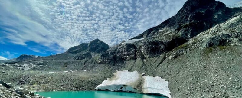
Iceberg Lake hike is one of the most beautiful hikes near Whistler, a 2-hours drive from Vancouver. This hike offers a spectacular view of the nearby peaks, meadows, glaciers, and Iceberg Lake.
Page Contents
Iceberg Lake Hike Summary
- Rating: Hard
- Round trip distance: 20 km
- Elevation Gain: 3900 feet
- Time Needed: 7-8 hours
- Type: Out & back
- Season: July to September
Iceberg Lake Hike Trail Guide
Iceberg Lake Trailhead & Parking
Here is the link to the Iceberg lake trailhead. The total drive time from Vancouver to the trailhead is around 2 hours. I would recommend starting early from Vancouver as the parking spots are located in a neighborhood and the spots are limited. There is no parking fee though.
There are a number of alternative ways to get to Iceberg Lake, but the one described here follows the 19 Mile Creek Trails all the way to the lake and back. The trails are a little confusing in the lower half, but sticking on the Lower 19 Mile Creek Route (also known as the 19 Mile Creek East Trail) will lead you to the Upper 19 Mile Creek Trail, and once there, this trail will take you to the Upper 19 Mile Creek Trail which takes you straight to the Iceberg lake.
Initial steep part & Gravel Road
As you start the hike, the initial part is steep and they lead you to a gravel road. Once you reach Gravel road, take a left there. You will also see a sign to take left there. There is also a lower 19 Mile creek trail sign there. After taking a left, continue straight for about 50 meters until you see another trail sign for the Iceberg lake or lower 19-mile creek on your right. Follow the sign and now you will enter a forest again. Soon, you will start crossing some streams
Bike Trail Crossing
You will cross bike trails at around 700 meters from the trailhead. After crossing the biking trails, the trail becomes a bit wider and steeper as well for the next 300-400 meters which take you to a fork
Screaming cat fork (@1.1 Km)
After 1.1 Km, you will reach another fork where you will see a sign showing a screaming cat connector and the Lower 19 mile creek trail. Keep following the lower 19-mile creek trail.
Upper 19 Mile Creek Trail (@2.4 Km)
After 2.4Km, you will reach another fork showing different trails such as Skywalk trail, Kevin’s Homerun trail, screaming cat lake trail, and upper 19 mile Creek trail. Follow Upper 19 Mile creek trail. From here, the trail becomes relatively flat and more scenic as you enter the forest for the next 1.5 Km
Bridge (@3.7 Km)
You will cross a bridge at around 3.7 KM from the trailhead. The trail gets steeper from here almost until the Iceberg lake. Also, the trail follows a waterfall (water stream) for most of the parts. Throughout the hike, at multiple points, you will see the waterfall from close. The hike becomes very scenic beyond this point.
First view of Peaks near Iceberg lake (@6 Km)
At around 6Km from the trailhead, you will get the first glimpse of the peaks surrounding the iceberg lake. The trail again becomes relatively flat from here for the most part until 200 meters from the lake.
Washroom (@6.2 KM)
You will also come across the washroom a few minutes after you start getting the view of the nearby peak. From here, the lake is almost a km.
Last steep part to Iceberg Lake 300 meters
Actually, the last one km part passes through meadows where you will see different wildflowers, rocks, boulders, surrounding peaks, etc. There is a steep section towards the very end that lasts for 300 meters and opens up at the Iceberg lake and now you are here.